|
| T R A V E L L O G |
 tj|ca|st tj|ca|st |
R O A D T R I P T O K A L I S P E L L , M T
Tuesday, July 27, 2004
I finally get all caught up on my sleep. After spilling out of bed I head to Sandpoint City Beach to cook a breakfast of scrambled eggs and oatmeal. After eating I walk over to Starbucks to webmaster the site, adding content covering the previous day's activities. Later in the afternoon I push off to Montana, destination Kalispell.
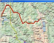
As the bird flies it's a little more than 100 miles to Kalispell from Sandpoint. Unfortunately, not being a bird, I find myself stuck driving the van and at the mercy of government's road planning ways. The quickest way to get there is to head North towards Canada for a bit then swing downward due Southeast, then East, effectively adding an additional 80 miles or so to my drive.
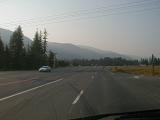
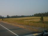
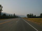
I encounter quite a bit of haze on my way out of Sandpoint, ID and it hangs around for pretty much the rest of the trip. I wonder if there are forest fires burning somewhere, belching out smoke and contributing to the poor visibility. As I drive to Kalispell, MT the Forest Service's "Smokey the Bear" signs are successively warning me of fire danger. In the areas I drive through the indicator hand (looks a little like the Twister's spinnable color indicator) always points to either moderate or high.
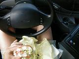
Dinner time has arrived so I get a large ham sub and eat it whilst driving. I'm steering with my left knee in this picture. I'm pretty good at driving with no hands and can actually navigate around shallow curves in a pinch.
Page
1
2
3
>>>
Prev Day |
Next Day
|